Torres Del Paine National Park – Patagonia, Chile

patagonia_map
Map of Patagonia, from National Geographic

At the very end of the world, in the most southern tip of South America, exists the land of wind, fire and ice known as Patagonia. This landscape of spectacular mountains, deserts, glaciers and alpine meadows spans across both Argentina and Chile, from the western pacific coast to the eastern atlantic coast. Curiously, the name Patagonia translates roughly to “land of the big feet”. It originated from the word “Patagão” (or Patagoni) – a name Magellan gave to the natives of this new land he encountered on his expedition in 1520. The Patagoni he described were actually the Tehuelche people, who in general, were much taller than the average European. Their large footprints found in tracks led the first explorers to believe that this was a mystical land of giants. The footprints were in fact large because of the leather skinned guanaco boots that they all wore during the cold winters.

36
View from the small Puerto Natales airport, staring into Patagonia

Patagonia is a land of secrets and wonder – even the story behind its name I found fascinating. It has long been at the top of my list of places to visit and finally on January 20, 2017 (inauguration day), we left Virginia to explore this untamed land.Traveling to Patagonia was no easy feat. After a 2 hour drive to Washington DC, we flew 5 hours to reach Panama City, and then 6 hours to Santiago, Chile. From there, it was a 3.5 hour flight to reach Puerto Natales followed by a 2 hour drive to reach Patagonia Camp. We broke up our traveling with a day’s rest in Santiago on both legs of our journey.

Map of Torres Del Paine National Park

I will never forget the flight to Puerto Natales Airport in Patagonia. The harsh winds created fierce turbulence and a hair-standing landing. Upon opening the cabin doors, our faces were hit with the howling winds and cold air of Patagonia. All around us in this desolate airport at the end of the world, were mountains as far as the eye could see…mountains, fields and emptiness. We would now have five full days to explore this mysterious land.

We grabbed our luggage amongst the dozens of hikers from all over the world and hit the road to Patagonia Camp (our base camp and home for the next 5 days). From here, we could rest and relax and plan our excursions into Torres Del Paine National Park each day. I hope to one day write a review about our experience at Patagonia Camp, but for now, all I can say is that it was simply an unforgettable experience with fantastic staff members.

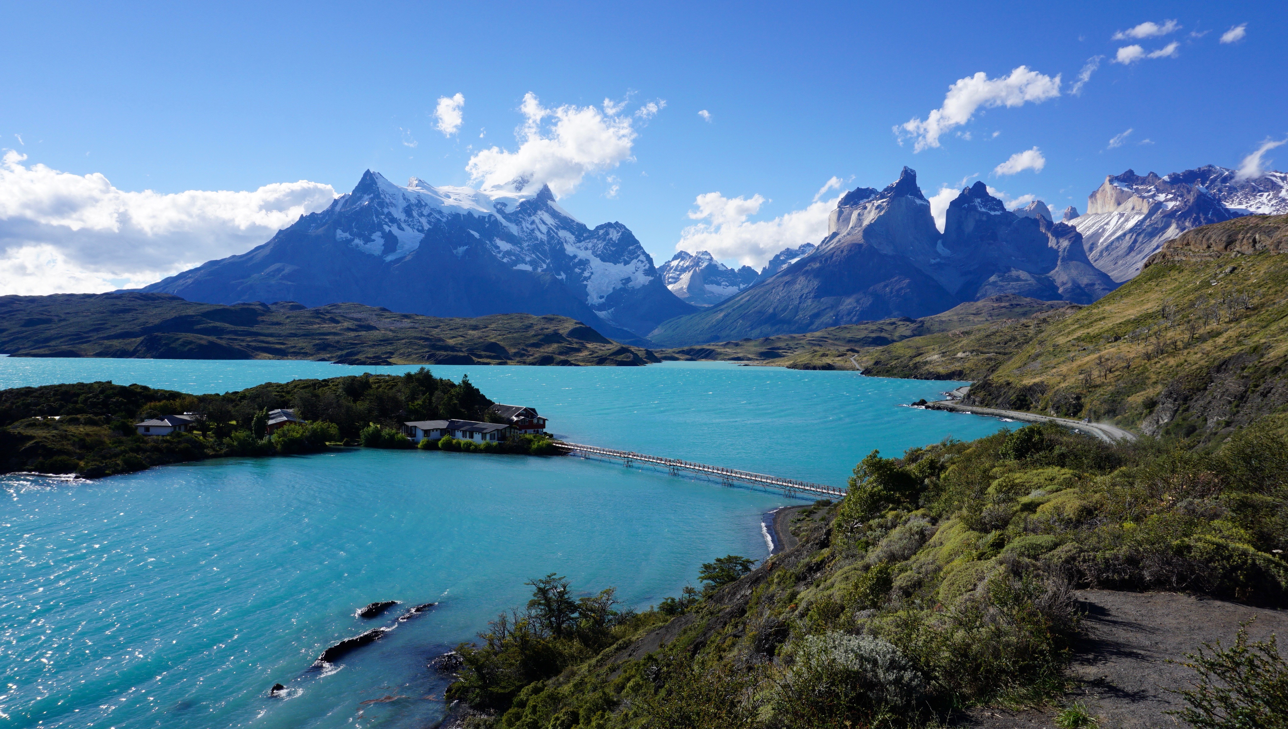
Torres Del Paine National is one of the most popular attractions in Chilean Patagonia. It is one of the 11 protected areas of the Magallanes Region and Chilean Antarctica. The park’s 2422 square kms of mountains, glaciers, lakes, and rivers attract thousands of visitors each year. The centerpiece of the park are the Paine (pronounced PIE-nay, meaning “blue”) mountains and more specifically the Towers of Paine (Torres Del Paine: spanish translation). These are three distinct granite peaks in the Paine mountain range that many consider to be the 8th wonder of the world.

Lago Pehoe

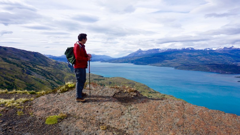
Our first full day in Patagonia was spent on an easy 8.5km hike through pre-Andean xerophilous scrubland. There was plenty of wildlife to see; guanacos, flamingos, condors and grey foxes. The most elusive animal in Patagonia is at the top of the food chain. The puma. I found this to be an unusual terrain for this predator, but clearly it was very successful. The fields were scattered with guanaco skeletons that were picked clean by condors after the pumas have had their fill. I was most in awe at how different everything was from any other place that I had been. The terrain, the geology, the wildlife, climate, and of course the flora.

One of the symbols of Patagonia is the evergreen shrub know as Calafate (box-leaved barberry, berberis microphylla). It is a plant native to southern Chile and Argentina  They were scattered through the fields during our hike and we were able to taste its edible blue-black berries. These berries were used frequently by the locals to produce all sorts of goods, such as jams, flavoring and even beer. Legend says that anyone who eats a Calafate berry will one day find their way back to Patagonia.

We continued our trek through the scrubland and explored caves with prehistoric paintings that dated over 6500 years old. We came back to camp that evening and met many of the other visitors. They were really from all over the world, Denmark, Canada, Britain and the USA. Most who come to Patagonia, travel here to hike the trail to the base of the towers, in the heart of the park. And some talented hikers showed us their watercolor creations of the towers once they reached the base. We were definitely excited for what lay ahead.

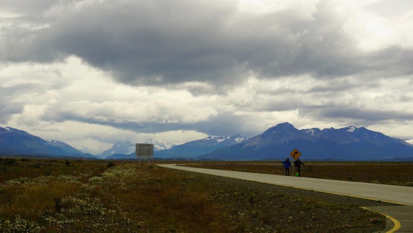
In Patagonia, the unpredictable weather makes trip planning essential, and you should always a back up option in mind if your primary objective does not follow through. In this sense, I felt that Patagonia camp did an excellent job of laying out potential options for the next day’s event. They were checking on the weather constantly to decide which trails when be optimal of the next days travel. This was of course a land where you can have all four seasons in one hour. The variability in weather was also drastic even in the smallest distances throughout the park. For instance, it could be pouring rain in the west end of the park and bright sunshine and clear skies on the east end over the mountain ranges. We had originally planned to go to the base of the towers on the second day, however storms had washed away the bridge access. We decided to shoot for the French Valley as the second option, however once we arrived, the ferry (which had been out of commission for the past 3 days) was full.

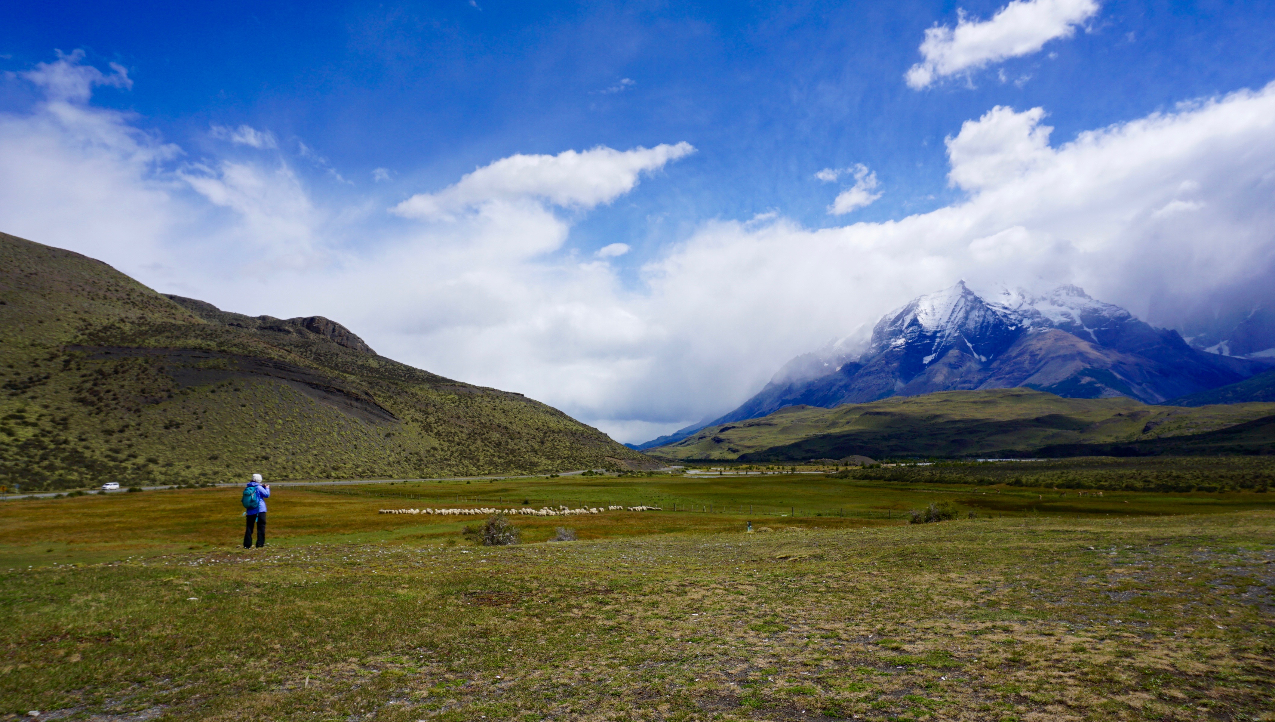
We went to our third option the Lazo-Weber trail. A 12km hike with a little bit more elevation climb than our first day but not incredibly strenuous. We hiked this trail in the opposite direction from west to east. This particular day ended up being one of our most beautiful days in the park. We were able to get great angles of the paine mountains and had amazing lookouts at the lagoons and meadows. This hike allows for one of the best views at Almirante Nito (8759ft), Los Cuernos (8530ft) and Cerro Fortaleza (9514ft) and the Paine Grande (10006ft). Our hike took us through meadows, forests and mountain tops. One of the most memorable moments for me was eating lunch inside a quiet forest, to shield us from the harsh winds. At the end of the 12km, was a small Patagonian ranch where we sat, ate lunches and drank.

On Day 3, we were itching to get into the heart of the park. We woke up early and head to the ferry to finally reach the segment on the “W” trail known as the french valley. It was a strenuous day of hiking, but the breath taking views, kept us pushing forward.

The French Valley – Patagonia, Chile

As we approached the glacier, we scaled rocks up melting glacier waters and crossed several wooden bridges. This is when things started to get interesting. At several parts of this trail, we were just basically fording through ankle deep glacier water. Once inside the French Valley, we found a quiet spot to eat lunch and gaze in awe at this magnificent glacier. We sat, ate, and listened to the cracking the glacier, as it continued it’s melt and freeze cycle in the summer time. After lunch, we filled our bottles with some of the best tasting glacier water I’ve ever had and caught the ferry to the mainland.

Before we knew it, our time in Patagonia was coming to an end. I can see how someone could easily spend several months here and still not see everything they wanted to. Although we were disappointed about not being able to see the base of the towers, we were grateful for so many things. Most importantly, no one got hurt and the weather was absolutely perfect. It had rained 50 days straight shortly before our arrival so we knew we were incredibly lucky. We visited during the Patagonian summer, and although we had incredible views. Some tour guides suggested to come back in the fall when the park is much quieter and the scenery is even more colorful with the fall foliage. The winds were also apparently less intense. It was not in our fate to see the base of the towers this go around, but I hope that the story  of the Calafate berry holds true – maybe one day, we will find ourselves back to this amazing land.

The Birth of a Dugout Canoe – by Northmen

I wanted to share this cool video released by Northmen Guild (formerly known as John Neeman Tools). They are a guild of northern European master craftsmen who use traditional craftsmanship handed down through many generations to create tools, vessels and goods.

“This is a documentary movie uncovering the difficult and time consuming process of making traditional expanded dugout canoe using mostly traditional hand tools and techniques.

The master woodworker in this movie is Richard (Rihards Vidzickis) – an experienced green wood worker, wood sculptor and dugout canoe maker. Richard’s passion to green wood and solid wood creations has grown together with him since his childhood days. Richard’s father is also a wood worker and carpenter and has led his son into the beautiful world of working with wood. Richard has gone through all the traditional steps of becoming a master woodworker – starting from an apprentice, then journeyman and then receiving his Master degree in Latvian chamber of crafts. Richard’s passion to wood is not only sculpturing and carving it but also knowing the wood in a scientific level. So Richard has studied in Technical university as a student and reached his degree of Doctor in engineering materials science, so he has combined the craft, nature and science in his life and work. While working in furniture making during the studies, with making different kinds of difficult wood carving for Jugend, Barrocal, Renesance design style furniture, Richard has discovered that he tends to get back to more rustic, robust and natural forms of wood, so he created a park of massive wooden sculptures, wood crafts museum and live workshop where Richard lives and creates wooden bowls, plates, boats and accepts visitors to share his work and lifestyle.”

The Canoe (film) – by Goh Iromoto

If you have 26 minutes, check out this beautiful film by talented documentary film maker Goh Iromoto.

“If it is love that binds people to places in this nation of rivers and in this river of nations then one enduring expression of that simple truth, is surely the canoe.”

This film captures the human connection and bond created by Canada’s well-known craft & symbol, the canoe. Through the stories of five paddlers across the province of Ontario, Canada – a majestic background both in it’s landscape & history – the film underscores the strength of the human spirit and how the canoe can be a vessel for creating deep and meaningful connections.

Filmmaker’s Note:

I started paddling around the age of 7, and thanks to the canoe, I’ve made some lifelong friends and connections, not to mention memories and stories, that I’ll never forget.

I wanted to show how several other paddlers similar to me have created strong intimate connections alongside the canoe. It really gave me great joy to see how rich the mosaic of stories I encountered were. Whether they were young or old, or from various cultural backgrounds, individuals were taking the traditional Canadian vessel and seeking new meaning with it. For me, the diverse paddlers I met represented a Canada that has grown and evolved since its birth 150 years ago – and something that I was able to stand proud of today.

I’ve continued to paddle my whole life and plan to do so for a very long time. Seeing and hearing these stories made me appreciate and realize how important the canoe is to my life. To all the paddlers out there (and to those who want to start!), this film is for you. Keep on paddling.

Thanks Goh Iromoto for making this awesome film!

The Canoe (trailer) – a film by Goh Iromoto

The canoe plays a pivotal role in the history of Canada. It was the vessel that allowed the voyageurs to utilize the rivers as highway systems for trade and expansion. It was the canoe that built Canada into the country it is today.  In the modern era, it serves as more than just a recreational vessel, but a symbol of Canada, and our heritage. I wanted to share this trailer of an upcoming film, scheduled to be released on 2/6/2017 called “The Canoe” by Goh Iromoto, which investigates the relationship of the canoe with the Canadian people.

“This film captures the human connection and bond created by Canada’s well-known craft & symbol, the canoe. Through the stories of five paddlers across the province of Ontario, Canada – a majestic background both in it’s landscape & history – the film underscores the strength of the human spirit and how the canoe can be a vessel for creating deep and meaningful connections.”

“Guided” trailer – Seedlight Pictures

“Guided profiles the gentle spirit of Maine wilderness guide Ray Reitze, in his element amidst the whispering pines, singing crickets and croaking frogs of the North Maine Woods. Ray shares his philosophy of how to live in harmony with the outdoors to the next generation of guides, grappling with his own mortality as he transitions from the physical world of guiding to a more spiritual understanding of nature and our ephemeral place in it.”

A cool video I came across, with some beautiful shots of the wilderness and canoe culture in Maine. Definitely looks like a place I’d like to paddle one day.

Happy New Years

screen-shot-2016-12-29-at-10-57-53-pm
The North Fork of the Shenandoah River

We spent Christmas in a cabin along the Shenandoah River, just west of Shenandoah National Park. The weather was warm enough to paddle, so we paired up siblings and went head to head in canoe races up and down the river. It was rare for all of us to have a holiday break together so we naturally had to make the most of this occasion. I had never been to the town of Shenandoah (population 2354 in 2013) before this outing. And as we drove through this sleepy town, it was hard for me to imagine that this place served a key role during the civil war. There were three iron ore furnaces around this town which smelted raw iron into pig iron. Apparently in the days before the war, this pig iron was shipped down the Shenandoah River to Harpers Ferry in West Virginia. During war time, these goods were transported by wagon to Gordonsville, VA and then subsequently by rail to Richmond where it could have been used at the Tredegar Iron Works. Both of these Virginia mountain towns now are peaceful and quiet as can be. I was especially impressed by Gordonsville’s display of Christmas Lights. It was certainly a welcoming sight while driving through the winding, dark and foggy roads of the mountains.

I just realized that I have not been able to produce any new videos of canoe trips this year. I have several projects in the works right now but they have yet to be polished. I’ve been very happy overall with the performance of the Sony a6000 both as a still and video camera. Lately I’ve been experimenting with different lenses and shutter speeds in videography and have been able to catch some pretty decent footage. For our trip in Quebec, I also brought along an external audio recording device to see how the audio quality would compare to the native mic. Here is a demo reel of random shots I was able to capture in 2016.

2016 Demo Reel: by John Le

As the holidays come to a close and a new year around the corner, I look back at how much time I was able to spend with family and friends and the total number of nights I camped outdoors. While it was a good year for paddling and hiking, the total number of nights I spent outdoors, totaled just five. Four of those nights were in the La Verendrye Wilderness Reserve of Quebec, Canada and the other night was spent camping in St. Mary’s Wilderness. I’ve made up my mind….in 2017, I’m going for double digits. Happy New Years to all!

dsc04209
Gordonsville, Virginia – all decked out for Christmas. In the middle of the Virginia mountains.

Camping in St Mary’s Wilderness – Raphine, VA

stmarys
St Mary’s Road is very well maintained, with a parking area before the trail head.

Virginia offers a truly diverse landscape to camp. From the sandy beaches of the eastern shore and Chesapeake bay to the blue ridge mountains and highlands to the west. Without a doubt, one of favorite places to camp, is next to a gently flowing stream in the mountains. I was recently on my one week vacation and I knew that at least one of these days would be reserved for some camping. My friend Min and I originally planned on camping at Ramsey’s Draft in the George Washington National Forest however we were unable to find any suitable campsites near the entrance. Ramsey’s Draft is a beautiful wilderness area I have explored previously, where giant hemlock trees once towered by a wild trout stream. The only problem was the hike to Hiner Spring and the campsites was several miles. We planned this trip as a relaxed camping trip, with minimal hiking and mostly focused on just cooking and fishing. So, we cut our losses and booked it for St. Mary’s Wilderness, a place where I knew there would be excellent camp sites along a river bed. We left the canoe at home this time and trekked in the old fashioned way – on foot. The first day was perfect, warm, sunny and dry. It took us only about a half hour to hike in to the first campsite. It was a perfect site situated at the river’s bend and allowed us easy access to clean mountain waters.

This grill, used on canoe trips served as a handy tool to cook steak.

One of the most exciting parts of camping in my opinion is setting up basecamp. There are numerous factors that go in to creating a comfy home in the woods, albeit just a temporary one. The heart of the campsite, the fire pit is the most important part. Building a structurally sound pit that allows for cooking and efficient heat dispersion is a skill that I still build upon. Always remember to take in account, the wind direction, the location of your tent in respect to the fire pit as well as position of your seats around the fire so you are not downwind of the smoke. Finding a suitable location of your tent is also important. Flat ground can be difficult to find in the forest. It is never a pleasant way to sleep when you are sliding down an incline in your tent. Sometimes, you’ll also have to clear a suitable grid, void of sharp rocks, sticks that may damage your tent. Also keep it out of the way of any standing, dead trees that could potential topple in a heavy storm. The pathway to water is one that has to be safely mapped so it can be accessed at all hours. Access to firewood is also important and Min loves collecting and processing firewood, it is something he takes great pride in. A folding saw, and axe are two crucial camp tools that allow a members to live comfortably. It gives you the ability to topple dead standing trees, and also quickly prepare a stack of firewood to last days.

After developing a strong base of embers from the fire, we stabilized the portable grill into the fire pit and cooked up some delicious steaks. It cooked perfectly, and we served it with some baked potatoes. As the darkness set it, we threw more wood on the fire and spent the night chilling and catching up about our jobs, families and friends. In the middle of fall, I was surprised to say it felt comfortable in St. Mary’s Wilderness. We were in short sleeve shirts in the middle of the night. Camping in the valley provided us with protection from the wind and we were sitting in low 60s F weather.

We slept well that night, however awoke to rain starting at 6:00am. It continued as an autumn shower without any signs of stopping. We packed up our gear and decided to head home. It had been a long time since i had been caught out in the rain, camping in Virginia and although it can be a pain, there is certainly a beauty to it. All around us, we could hear the drops, beating on trees and plants, as leaves drifted in the forest all around. The river beds were fast to fill, especially since we were in the valley. The water was teeming with wildlife, brook trout, frogs, and countless crawfish made their appearance. The rain seemed to awaken the forest. Just goes to show you that if you only camp when the weather is nice, you’re missing half of what’s out there.

Blackrock Summit – Shenandoah National Park, VA

Screen Shot 2016-07-25 at 7.16.39 PMIt was a particularly hot summer weekend in Charlottesville, with highs greater than 100 degrees F. We were on a getaway from Richmond and despite the heat, we somehow wanted to squeeze in a quick hike in Shenandoah National Park. During this time of year, the popular watering holes like White Oak Canyon, are packed, so we decided it was time to find a new trail.

In the heat and humidity, we had to be conservative with what we hoped to accomplish. Naturally, we chose the easiest hike in the park: Blackrock Summit, a quick 1 mile loop around the mountain and back. This was more of a walk than a hike. The elevation was minimal and the trail very well maintained. Despite the ease of the hike, the vistas were awesome. Climbing upon the rock bed at the top allowed a full 360 degree view of the park and surroundings. The formation of the rocks at the top were certainly unusual and even appeared out of place. With the help of some trail signs, we were able to learn that this was once the floor of the ancient Iapetus Ocean that predates the Appalachian Mountains. Over time, geological forces transformed the seabed into solid quartzite rocks. Overtime, this region too will become overgrown with vegetation and will look like the surrounding mountains.

We reached the top in the early morning and descended the mountain just as the sun reached it’s peak. We sought refuge in the canopy of the forest where it was at least 10 degrees cooler. We searched for mushrooms and marveled at the lush forest in the peak summer time. It had been too long since my last visit to Shenandoah National Park, this outing reminded that she always has something special to offer in every season.