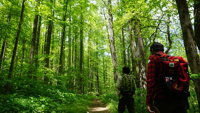
It was a particularly hot summer weekend in Charlottesville, with highs greater than 100 degrees F. We were on a getaway from Richmond and despite the heat, we somehow wanted to squeeze in a quick hike in Shenandoah National Park. During this time of year, the popular watering holes like White Oak Canyon, are packed, so we decided it was time to find a new trail.
Shenandoah shrooms
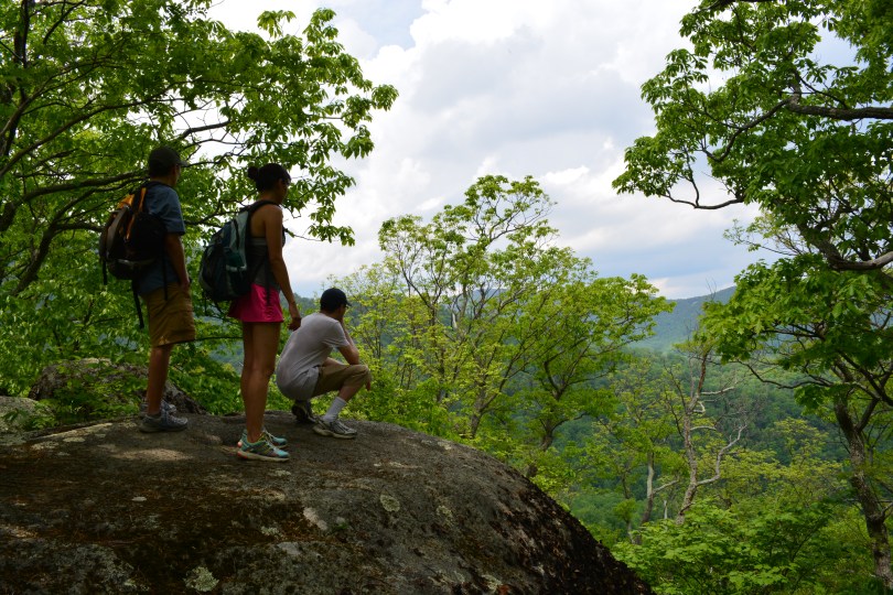
In the heat and humidity, we had to be conservative with what we hoped to accomplish. Naturally, we chose the easiest hike in the park: Blackrock Summit, a quick 1 mile loop around the mountain and back. This was more of a walk than a hike. The elevation was minimal and the trail very well maintained. Despite the ease of the hike, the vistas were awesome. Climbing upon the rock bed at the top allowed a full 360 degree view of the park and surroundings. The formation of the rocks at the top were certainly unusual and even appeared out of place. With the help of some trail signs, we were able to learn that this was once the floor of the ancient Iapetus Ocean that predates the Appalachian Mountains. Over time, geological forces transformed the seabed into solid quartzite rocks. Overtime, this region too will become overgrown with vegetation and will look like the surrounding mountains.
We reached the top in the early morning and descended the mountain just as the sun reached it’s peak. We sought refuge in the canopy of the forest where it was at least 10 degrees cooler. We searched for mushrooms and marveled at the lush forest in the peak summer time. It had been too long since my last visit to Shenandoah National Park, this outing reminded that she always has something special to offer in every season.
The Rapidan River is one of my favorite rivers in Virginia, especially the segment which courses through Shenandoah National Park. The flowing cascades, peaceful scenery and good population of brook trout has earned this river a top 100 trout stream spot according to Trout Unlimited coming in at #38.
Shenandoah National Park
The Rapidan plays a significant role in history as well. Originally named the Rapid Anne river after Queen Anne of England it has since changed it’s name to “Rapidan”, a combination of the words “rapids” and “Anne”. The river was also the site of numerous, bloody, civil war battles. After the war, it’s beauty continued to attract visitors from all over. It even caught the eye of one of the US Presidents. During the Hoover administration (1929-1933), Camp Hoover was built by President Herbert Hoover and his wife Lou Henry Hoover to serve as their wilderness getaway, where they fished these pristine waters. The camp still stands today, although officially named Rapidan Camp now and open to the public, situated at the beginnings of the Rapidan River.
peace
stream hopping
lunch
home of the brookies
I was glad that at 15 years old, our Jack Russell Terrier was able to join us on this trip. He thoroughly enjoyed himself although he did not swim much as the current was fast flowing and the waters frigid. We leisurely climbed from stream to stream casting our flies. Before we knew it, the sun was setting and we had been out for over seven hours. Although we caught nothing (no surprise), we had several bites and I got my brother hooked on the sport. He just told me the other day, he was looking for a rod.
Casting
trout stream
cascades
While we have fished all of our lives, Tenkara is a whole new ball game. It is a form of traditional Japanese fly fishing without the use of a reel. This allows everything to be packed nicely into my backpack without the need for tackle box or much gear. Essentially it is just rod, line and fly. The rod itself collapses to just over 20 inches. I found Tenkara to be a much more active form of fishing which I thoroughly enjoy. First off, your main target is trout, and here in Virginia, they are found only in the coldest and cleanest mountain waters. A hike of some sort is almost always needed. Secondly, while you’re fishing, you’re constantly casting and moving from one spot on the stream to another. The only thing about this time of year is that it is tick season! I pulled one off myself and a couple off of our dog. Nasty little buggers that on rare occasions can serve as a vector for transmitting Lyme Disease. I always try to be good with tick checks before getting back in the car. Spraying your shoes and lower legs with bug spray will definitely help as well. Ticks are typically found south of the Canada-US border although of late, climate change has changed that, with reports of tick bites becoming more and more common in Ontario.
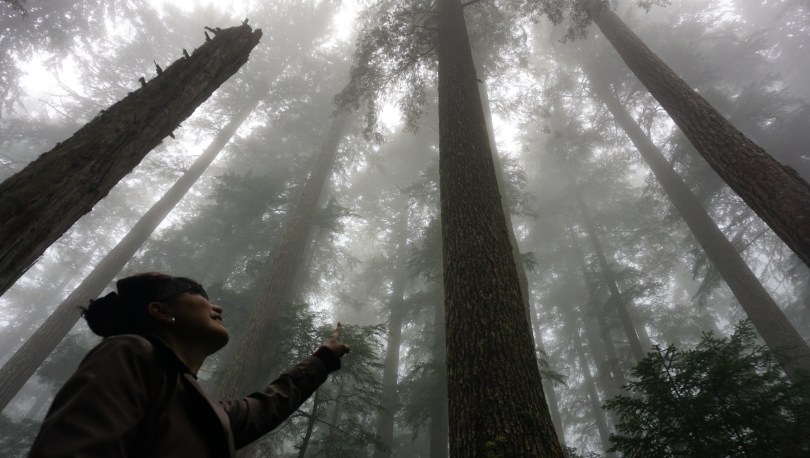
With so many famous parks to see in the pacific northwest, It was difficult to choose one to explore. In a split decision between Olympic National Park and Mt Rainier, we opted for the latter. Mt Rainier holds the title as the fifth national park in the United States and is famous for the subalpine meadows, old growth forests and 25 glaciers. The centerpiece: the stratovolcano that towers over 14 000 ft, known as Mt Rainier. Apparently, summer is the best time of year to visit, when the skies are clear and the best views can be obtained. In the early spring, it was wet, rainy and foggy. One step into this landscape and we knew we were in temperate rainforest.
fun guys
river
canopy
The land is certainly different from the eastern forests that we are used to in Virginia and Ontario, the ground is lush with vegetation and water seemed to be present in all nooks of the forest. Small streams seemed to course their way through the entire forest. The evergreens, towered above us and created a canopy unlike any that I’ve seen. As with most things, our time here was much too short. Magical park.
The Chesapeake Bay is a short 1 hour drive away from Richmond, VA.
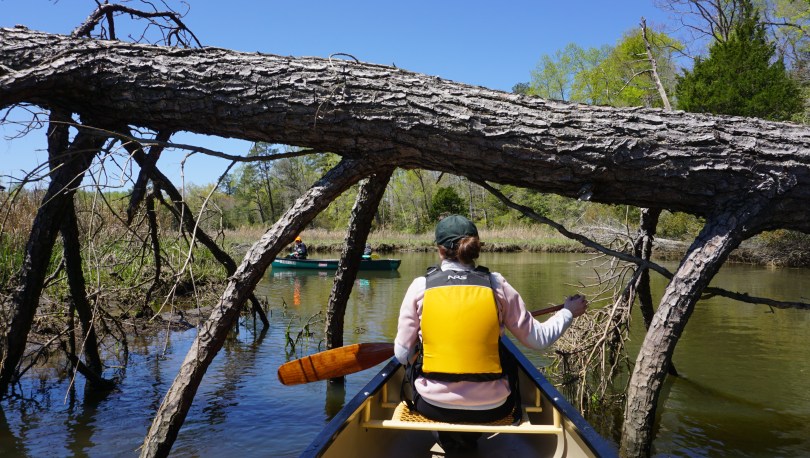
There is never a shortage of waterways to explore in Virginia. In a short 1 hour road trip from Richmond, one can reach the largest estuary in the United States; the Chesapeake Bay. Here, fresh water from over 150 rivers and streams of New York, West Virginia, Pennsylvania, Delaware, Maryland, District of Columbia and Virginia meet the Atlantic Ocean to create a brackish water ecosystem teeming with diverse wildlife and vegetation. There isn’t a better way to connect with this landscape than by canoe. We decided to paddled through the south arm of the Ware River, one of five canoe trails that make up the Gloucester Blueways. The county established these Blueways as a way to encourage visitors to the area and to encourage preservation of these precious lands.
Unloading at the Mobjack Bay
The population of bald eagles and osprey has been healthy in recent years and we had were within sight of them the second we reached the put in. The salty waters of the Mobjack bay was surprisingly clear and calm as we embarked on our excursion.
The launch
A sense of calm and stillness surrounded us as we approached the wetlands. We were protected from the wind by reeds and twists of and turns of the stream. I was stunned by the vast array of wildlife we encountered. From blue crabs, to herons and even a red-tailed hawk, each bend of the river presented a new surprise.
There is certainly something very special about the wetlands. For years the Chesapeake Bay Foundation has been fighting to protect these lands. These regions are especially important in preserving the clarity of the Chesapeake bay. It is the final stop for all of our river and stream runoff from land before it reaches the bay. The major pollutants of the bay are in the form of nitrogen and phosphorus. Such elements are crucial to life, however an overabundance can be detrimental. When these elements are in excess, they contribute to algae blooms which clouds the water and inhibits sunlight that is crucial to the growth of bay grasses. The decline in oxygen from dying plants can cause dramatic pH changes which can kill off crabs, fish and more plants. Today, 300 million pounds of polluting nitrogen reaches the bay each year, over 6 times the amount that reached the bay in the 1600s.
Bald Eagle in flight
Floating
blue crab
osprey country
into the wetlands
While the war effort in cleaning the bay is underway on many fronts. Many believe that the oyster will be the savior of the bay. The eastern oyster is an incredibly resilient species, although years of disease, pollution and over harvesting have caused numbers in the bay to decrease to less than 1% of what it once was. This shift in oyster population has also contributed to the decline in the health of the bay. Oysters are able to filter up to one gallon of water in one hour. They play a vital role in preserving the clarity and hence the habitat of the Chesapeake Bay. In the recent years, the news has been promising with oyster populations making a bounce back and with them, the blue crab population. Both iconic species of the Chesapeake Bay.
I had some time at the end of this trip to reflect on some tripping gear as well. This was my third outing on the prospector, and so far she has been handling like a dream. At only 52 lbs, she’s a breeze to load onto the car and take anywhere. She is responsive and feels comfortable on all different types of water. The comfortable yoke design also makes her almost a joy to portage…but i wouldn’t go that far. I’ve also been quite happy with the Sony a6000 mirrorless camera I’ve been shooting with. I’ve realized that I normally shooting in fairly wide angles at an average of 16mm. Although I haven’t used many other lenses other than my portrait 35mm, I can definitely see the utility in the zoom lenses >250mm in capturing wildlife. The eight bald eagle sightings on this trip convinced me to at least look into some of these lenses.
Mobjack Bay, Virginia
The scorching Virginia summers often steer our canoe trips to the cooler mountain lakes, however this is spring, and anything is fair game. It was actually a refreshing and chilly day as we paddled, at temperatures in the 50s F. Let’s see how long these cool temperatures last. With the north arm of the Ware River and four more routes to explore on the Gloucester Blueways, there’s still plenty to see. Long live the Chesapeake Bay.
The trail to the waterfalls follows St. Mary’s river as it meanders through the Blue Ridge. Follow the pink ribbons to reach the falls.A 2 hour drive to reach the well maintained St. Mary’s Road. Approach the trail from the Cold Springs Road.
When presented with free time and the opportunity to explore arises, it can be difficult to decide where to go. The number of destinations seem endless with each place offering something completely different: the Blue Ridge mountains to the west, the coastal tidewater to the east and the Appalachian plateau to the Southwest. I usually end up letting the season and conditions deciding for me. What better place to explore in early Spring than the St. Mary’s Wilderness Area in the Blue Ridge? I read numerous reviews about the area of its beauty and clear river beds. St. Mary’s is designated a wilderness area, and as such, the trails are poorly marked. It appeared that summer hikers frequently got lost on the poorly marked trails and overgrown brush. I hoped to avoid all of this by navigating in early spring, with bare trees and clearer paths.
Rock hopping
St. Mary’s Falls
Trail Markers
Pink ribbon marked the trail
Honey wine
Spring flox
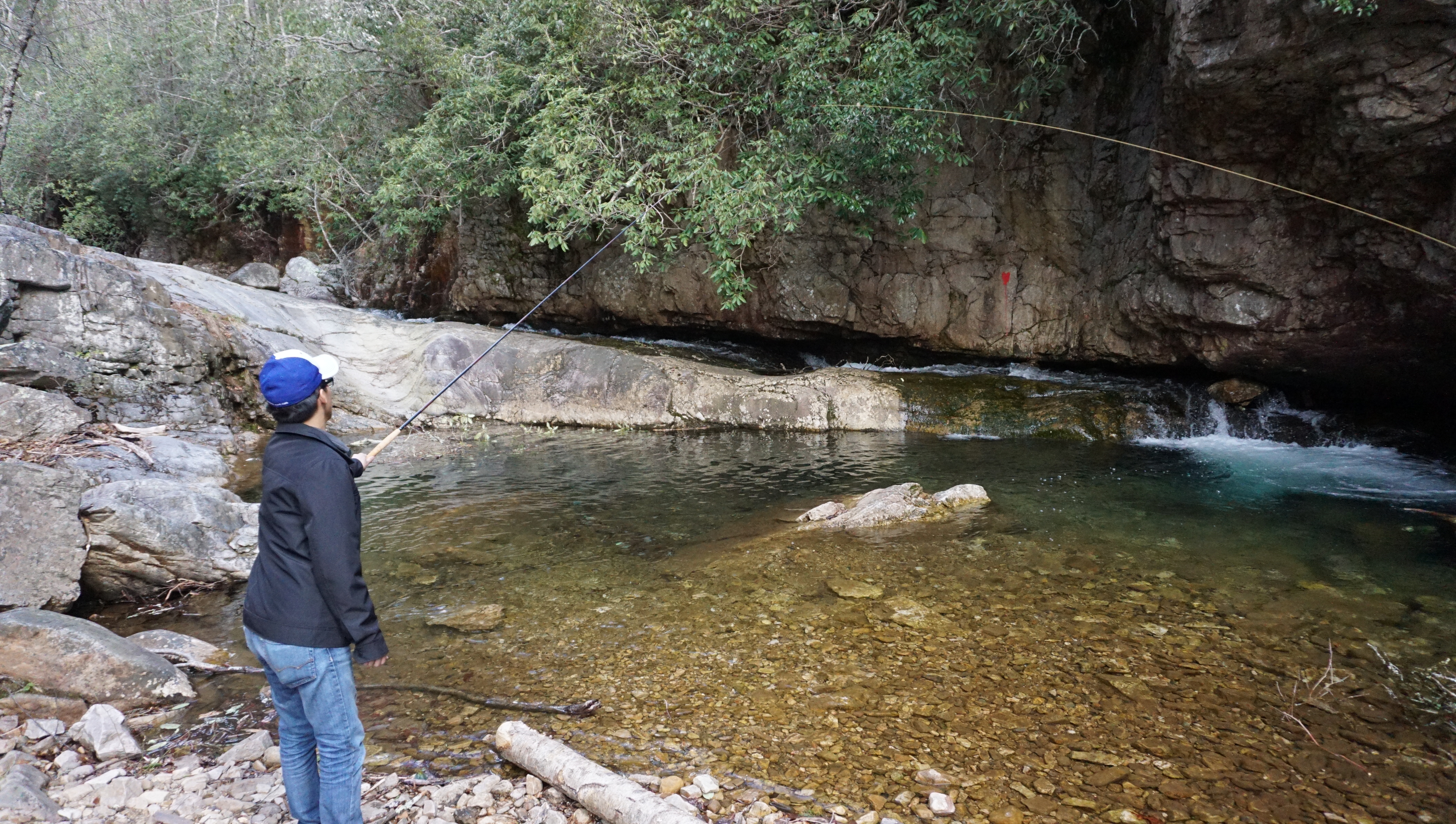
My cousin from Toronto accompanied me on this outing, marking his first proper hike in Virginia. When we arrived to the trail head, I was surprised to find that the earth was scorched and the trees charred. I later learned that a wildfire just two weeks prior had burned over 800 acres of the wilderness area. St Mary’s spans over 35,000 acres making it the largest Virgina Wilderness area on national forest land. The region was previously a mining ore for manganese and iron until it was abandoned in the mid 1900s. Today it serves as a beautiful hiking and fly fishing trail along the St Mary’s River, complete with a beautiful waterfall at the end.
Making a dry crossing
Canyon view
There are numerous routes to get to the waterfall. The most popular route listed on Hikingupwards.com recommended starting out along the Blue Ridge Parkway. One reviewer discouraged this path, because it was poorly marked and he took numerous detours after getting lost. They recommended an easier way to get to the falls. Off of Cold Springs Rd (Route 608) is St Marys Road. This road is in excellent shape and leads you all the way down to a well kept parking area and the beginning of the trail that puts you right next to St Marys River. From there, you simply follow the river to the falls. Internet win.
We tried our hand at some Tenkara, a form of Japanese fly fishing that does not require a reel.
The hike twists and turns through a beautiful gorge, providing a unique vista in Virginia. There was lots of rock hopping, and scaling as the trail crossed back and forth over the river five times. We tried our hand also at some Tenkara (traditional Japanese fly fishing). This style of fly fishing uses only a rod, line and fly – no reel. With flask in hand with some Nordic honey wine and packed lunches, we enjoyed the peace of spring time in the mountains.
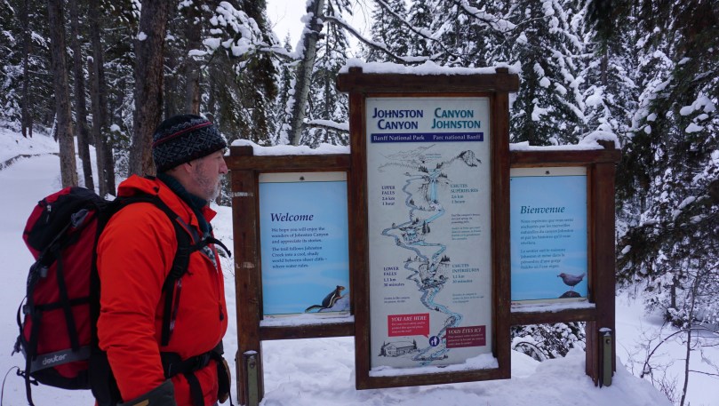
One of the most popular attractions in Banff National Park is the Johnston Canyon Falls. It is a short hike at less than a couple of miles, but spectacular throughout the entire way. In fact, before even reaching the falls we were fortunate enough to get a moose sighting in Moose Meadow. I was curious as to what brought moose to that particular meadow. I was interested to learn that moose are not grazers, and as such they eat forbs and other non-grasses which are plentiful in this meadow. Frequently they are seen feasting on aquatic plants. This particular moose was interested in our vehicle and actually stopped eating to come check us out. It then peacefully, went on its way. It was a very nice welcome from a resident of Banff National Park.
The route
In the summer time, the Johnston Canyon trail is packed elbow to elbow, however during the winter, it is a quiet, icy wonderland. We strapped crampons to our boots to allow for traction while navigating the trail. We followed the Johnston creek as it coursed it’s way through the limestone valley. A steel catwalk system is bolted to the cliffs through the valley for easier navigation and to keep visitors above the water.
glacier flow
bent tree
catwalks
old man’s beard can be used for several things including serving as excellent tinder
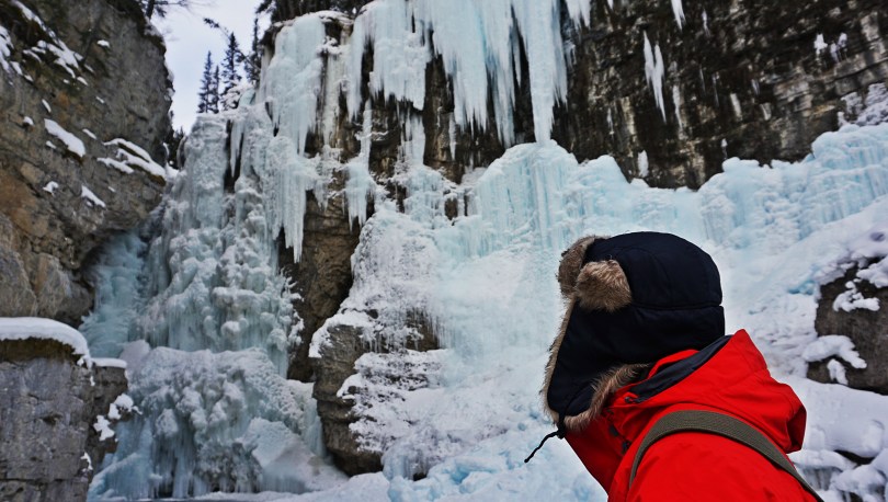
The forces of nature are displayed brilliantly in Johnston canyon. The beautiful limestone that encase the valley, reveal a history of thousands of years in its cross sections. The retreating ice glaciers that once covered the region, molded the landscape to what we see today. Trees all around us are literally bent from the many months of heavy snowfall throughout the year. Thick old man’s beard (lichen) draped over the towering firs and the turquoise, glacier water flowed around us, flickering from the ice and sun.
limestone cave
cave falls
Upon reaching the lower falls, we had the opportunity to navigate the limestone caves to view the falls from the shadows and listen in awe to the echos of the rushing water. After a short break, we continued on to the upper falls where we had some warm tea and granola while watching ice climbers brave the falls. The view from the top was stunning. Beyond the upper falls is a region called the Ink Pots, where apparently seven cold mineral springs can be found in open meadows.
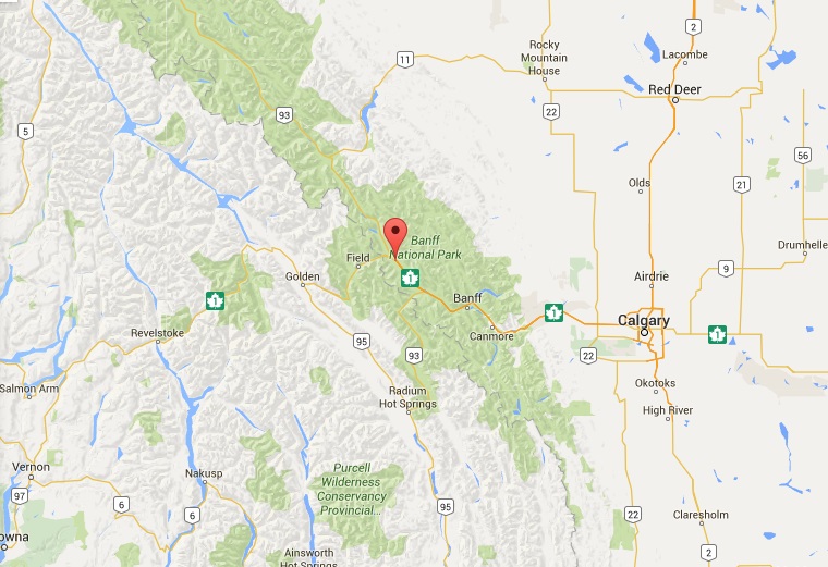
I have always wanted to see Alberta. Ever since my elementary school days, I remember completing research projects and hearing about the great national parks of the Rockies and knew that one day I would have to visit them. I just never thought it would be in the winter. We were fortunate enough to get vacation together and made our way to the great province of the strong and free. One of the best ways to trek through this winter wonderland is by snowshoe. Sarah and I set out to the woods around Lake Louise to have our go at traditional snowshoeing. Our guide, Paul, works at the Chateau Lake Louise, and has been leading trips through Banff for the past 30 years. He was a knowledgable man who had great respect for nature, ecology and the First Nations people. For the First Nations people who originally lived in the area, snowshoeing was much more than recreation, it was a way of life.
Different snowshoes for different environments
Ojibwe snowshoes, note the narrower profile for weaving between trees.
Paul emphasized, “there is no such thing as a perfect tool”. Each type of shoe was designed by different tribes who lived in different environments. The western prairie snowshoes were very wide allowing for the greatest distribution of weight. The people of these regions did not have to worry about navigating through trees and dense forests. The Algonquin and Ojibwe people however, made their shoes longer and more narrow to weave in and out of trees.
Lake Louise
listening to the forest
fir trees
snow angels
on the move
road
One of 5 bicentennial canoes, this one named “Osprey” undergoing restoration.
The temperature was actually quite warm for the region at about -15 celsius, with fresh snow falling. As we made our way through the trails, I was surprised at just how well the shoes worked. We glided through the forest with ease and comfort. Fir trees towered all around us and we trekked kilometers in peace and quiet with the magnificent sight of the Rockies all around us. I was also surprised to learn that Paul constructed several of his own shoes. These beautiful shoes were not only pieces of art, but more importantly for the First Nations people, an essential tool for survival during the harsh Alberta winters.
The morning air is crisp, and the leaves are beginning their color change, the first day of autumn is officially here. Min and I set out to our familiar backyard, Shenandoah National Park. Instead of scaling the mountains and searching for high altitude vistas. We sought out watering holes, cascades and native brook trout that lived in these crystal clear, mountain streams.
The route: From the parking area, we took a left up the Cedar Run trail and crossed the fire road to descend down White Oak Canyon Trail.
Our trip took us past Madison, VA close to Old Rag Mountain, however this time through the Weakly Hollow Road. From there we parked our cars, and headed to the intersection between Cedar Run and White Oak Canyon trail. Instead of going the traditional route straight up White Oak Canyon, I’ve found out from many reviewers of this hike, that the best way to go, is up the Cedar Run trail. It eventually connects with a fire road to close the loop with a descent down the White Oak Canyon Trail. The total circuit would be 8 miles. I definitely recommend this method of approaching the trail for anyone thinking of doing this hike, the climb up Cedar Run is gradual as opposed to the vertical climb up White Oak Canyon. This route also allows you to descend down the fire road instead of climbing it where there really is not much to see.
It was a perfect day for a hike, a cool 65 degrees F in the morning and sunny. The water level was relatively low and some of the of the creek beds were completely dry. Nonetheless, there was still plenty of water to enjoy the beautiful falls. We saw plenty of brook trout in the these streams as well.
Salvelinus fontinalis (brook trout) are a native fish to the Shenandoah Mountains.
Brook Trout (Salvelinus fontinalis) are part of the Salmonidae family and more specifically, a type of char. Other members of this group include arctic char and lake trout. As such, brook trout require water temperatures less than 20 degrees celsius to flourish due to the higher oxygen content. In the mountains, the native fish live relatively short spans of about 3 years, although some may live up to 6 years. Typically, brookies found in the streams grow to around 6-12 inches, larger sizes can be reached if they make it to a lake where food is abundant. They spawn during mid to late fall. Brook trout are amazing fish. I am always in awe at how they are able to survive in such low waters and through times of drought and flooding. Year and year again, they return and swim in the streams of the Blue Ridge Mountains.
The loop took us a solid 5 hours with a swimming break in a pool in a small canyon. The water was absolutely freezing but we knew that this was probably the last chance we would have this year before it gets too cold. As cold as it was, the water felt amazing, to swim with the brookies was also an awesome experience. Some of the watering holes even have natural water slides to enjoy during the hotter months.
small waterfall
streams
a deep pool along cedar run trail
acorn
rock cliff
cascades
cairn
Overall, an enjoyable hike and highly recommended as a place to cool off in the summers. If I were to return, it would be in the spring or early summer months with higher water levels and with my tenkara rod in hand.
I was starting to wonder if I was ever going to make it out to the mountains before spring ended. We got our chance on May 16, 2015 when our cousin from Toronto came to visit. It was his first time to Virginia and this would be his his first hike through the Shenandoah mountains. It was a perfect day for the Bear Church Rock loop (8.5 miles) which initially starts on the Graves Mill trail before steeply climbing the mountain along the Staunton river trail. We included a detour to check out the Jones Mountain Cabin owned by the PATC (Potomac Appalachian trail Club). It was a hot day with some overcast mixed with bursts of sunshine and spring rain. The showers peaked as we reached the top of the mountain to cool us off. Heaven.


 It was a particularly hot summer weekend in Charlottesville, with highs greater than 100 degrees F. We were on a getaway from Richmond and despite the heat, we somehow wanted to squeeze in a quick hike in Shenandoah National Park. During this time of year, the popular watering holes like White Oak Canyon, are packed, so we decided it was time to find a new trail.