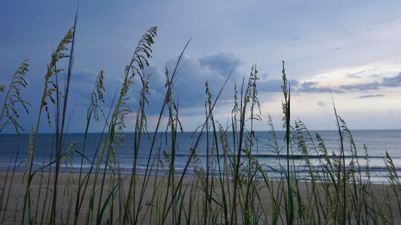
The Outer banks, a string of barrier islands off the mainland from North Carolina is a slice of heaven. We come here every year. I was lucky enough to be able to spend two weeks here this past summer. Here are some of my favorite shots of the horizons of the Outerbanks. Shot on Sony a6000.
Beach in NagsheadNagshead6:00am, Nagshead Finished for the daySunsetCrimson Storm approachesTown of Nagshead
The Eastern Shore of Virginia is separated from the mainland of Virginia by the Chesapeake Bay. This 70-mile long stretch of sandy and deep soil terrain is a peninsula with over 78,000 acres of protected parks, refuges and preserves and a national seashore. The region’s tourism affirms “You’ll Love Our Nature”.
Many travel by golf carts in Cape Charles. Several of the houses even have parking spots for them.Admiring the local art This town loves Yellow Roses, for good reason too
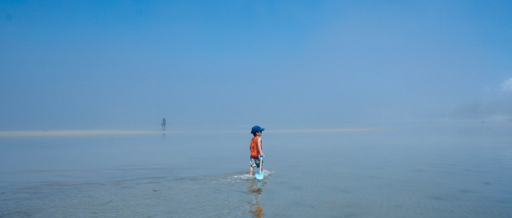
Cape Charles is a small town, at the southern tip of the eastern shore, with a population of 1009 (2010 census) yet it boasts a vibrant, historic downtown, beaches, restaurants and a quaint and charming scene. I love communities by the ocean. There is something carefree about being able to here’s something about being able to smell the ocean while walking through neighborhoods that puts you in a carefree mood. The slow pace of the town, follows the cadence of the gentle waves that roll in from the bay – the beaches are very kid-friendly for this reason. The beach faces west toward the Chesapeake Bay and hence has very flat water, it is protected from the Atlantic Ocean.
Between the reflection of the water, the clouds and the parallels…..sometimes it’s hard to figure out where you are! Virginia is for lovers.Lots to discover at the beach
With a newborn in tow, we couldn’t ride the golf carts. But bicycling was even better for the kids. The quiet town had plenty of sidewalks for the kids to zip through safely. There were lots to see, ice cream shops, gift stores, restaurants and history. Central Park in the heart of the historic district was a place that we frequented for its large field and playground area.
Central Park in historic cape Charles
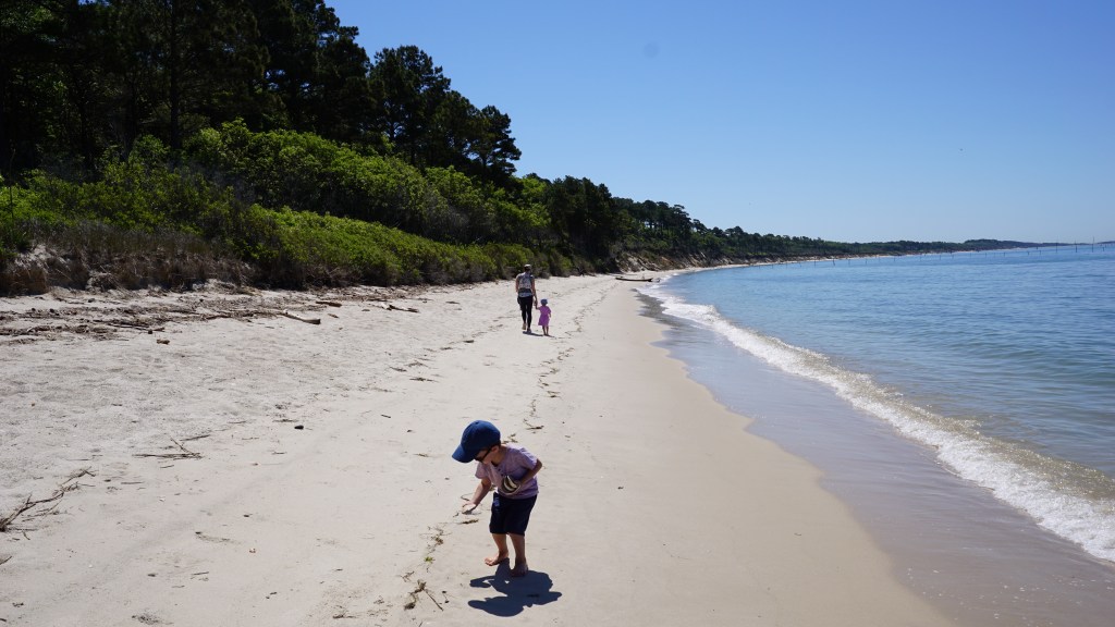
Our last full day was spent exploring Kiptopeke State Park, located at the southern tip of The Eastern Shore. It was an easy 15 minute drive to the park entrance. This state park is known for it’s migratory bird watching, beaches and The Concrete Fleet, several concrete ships that were partially sunk to create the Kiptopeke Breakwater. During World War II, 24 concrete ships were contracted by the U.S. Maritime Commission, in 1948, 9 of these ships were brought to Kiptopeke to protect the ferry terminal during severe thunderstorms. The Chesapeake Bay Bridge Tunnel was open in 1964 and the terminal was no longer needed. The concrete ships are still in place to serve as a break water for the beaches.
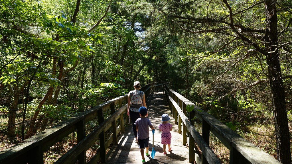
Balancing on shone driftwood in kiptopeke state park. In the distance the concrete fleet stands guard. The shaded boardwalk leading to the beach is a pleasant hike.Board walk to the beach.
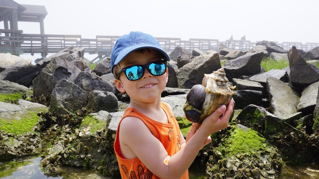
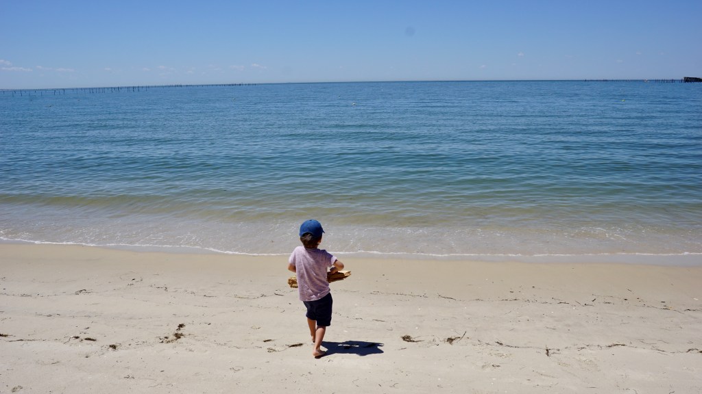
A 0.3 mile board walk through the shaded beach forest takes you to the beach. We arrived in the early morning, and had the beach to ourselves. We spotted a nice shaded area along the tree line some ways away. It was a bit of a hike to get to, but was pleasant and the kids collected shells along the way. The water was clear and the views were great.
Heading to the shadeTesting the buoyancy of some driftwoodA shell paradise
Before we knew it, our 5 days were up. There was much to still see of the eastern shore. Alas, Tangier and Chincoteague Islands will have to wait for another trip. We explored only the southern tip of the eastern shore, and it was pretty awesome.
After almost 2 years of growing, my son and I were excited to harvest our first bag of Chesapeake Bay (Eastern/Virginian) oysters. It has been several months since our last check on the float, we found the whole thing was actually submerged due to the weight of the now much heftier oysters. This was really not an issue, as the oysters were protected in a cage. When we initially placed these guys in their cage, they were called “spat” not much larger than big sunflower seeds. After 2 years of filtering the brackish waters of the bay, several of these guys were actually larger than 4 inches! This was our first growth cycle, and it has certainly been an interesting and fun experience.
April 2022
While we sat around the grill preparing a feast, we reflected on what we have learned:
Raising oysters is very easy. If you have a sturdy oyster float, and access to the water, you can raise oysters. They really don’t require much. They simply need to be upsized into bigger bags and cages and they grow. This is usually done every several months. If you also want to keep them separated and growing beautifully, shake and jostle them around in the bags so that they don’t grow to one another. This will also cut down on barnacle growth. Hosing them down every once in a while, will also keep algae off and keep them in better shape for harvesting and bringing to the table.
The spat is not expensive: $35 can buy you a bag of 1000 oyster spat.
1 oyster can filter 50 gallons of water in one day. This is why they are essential animals in the battle of cleaning up the Chesapeake Bay.
The “R” rule doesn’t necessarily pertain to these types of oysters (triploid, sterile) . Seafood enthusiasts have always followed the “R” rule when it came to eating wild caught (diploid) oysters: “Eat wild caught oysters only during the months with the letter “R” in it.” There are two reasons for this rule.
Food safety: eating raw shellfish, always carries the risk of food borne illness from bacteria such as vibriosis (caused by the bacteria vibrio vulnificus). The risk of contracting this illness is higher during the summer months when the water is warmer. The reality is that this illness can be contracted from eating raw shellfish during ANY time of the year. It is more prevalent during the warmer weather however due to more favorable conditions for the bacteria to proliferate. Properly cooking your oysters can virtually eliminate the risk of catching this infection. The CDC estimates that approximately 80,000 people get vibrio infections each year and 100 people die from it each year in the United States. I always eat my oysters cooked.
Taste: Wild oysters are diploid organisms, meaning they carry a set of chromosomes from each parent. Farm raised oysters for the most part have been selected and altered to be triploid, meaning they actually carry an extra set of chromosomes. These oysters are sterile and do not reproduce. During the warm summer months is when wild oysters are active in the reproduction cycle. During this time, the oysters under go physiologic changes which alters their taste. They are more watery, bitter and just not tasty. Many of the restaurants that serve oysters year round, serve farm raised, triploid oysters. Triploid oysters grow faster because they do not go through the reproductive cycle. All o their energy is put towards getting larger. They grow to bigger sizes and they maintain their taste throughout the year.
Oysters are highly nutritious!
Eastern Oyster (Crassostrea virginica) nutrition facts per 3.5 oz serving. (Approx 3 oysters)
Calories: 79.
Protein: 9 grams.
Carbs: 4 grams.
Fat: 3 grams.
Zinc: 555% of the Daily Value (DV)
Vitamin B12: 538% of the DV.
Copper: 493% of the DV.
Selenium: 56% of the DV.
7. Be safe when shucking oysters. Wear proper gloves when handling the cages and the oysters as their shells can be razor sharp.
Deep Bottom Park is special not only for its historic significance, but also for its position on a unique part of the James River known as — the oxbow. The U-shape bend of the river at this section of the James resembles the harness for an ox. The river in this section is also unusually deep, hence the name of the park.
“…Gabriel Archer, who along with John Smith and a band of other Jamestown colonists first traveled through here in May 1607, estimated the depth at “five or six fadom eight oars’ length from the shore.” ” – National Park Service, US Department of Interior.
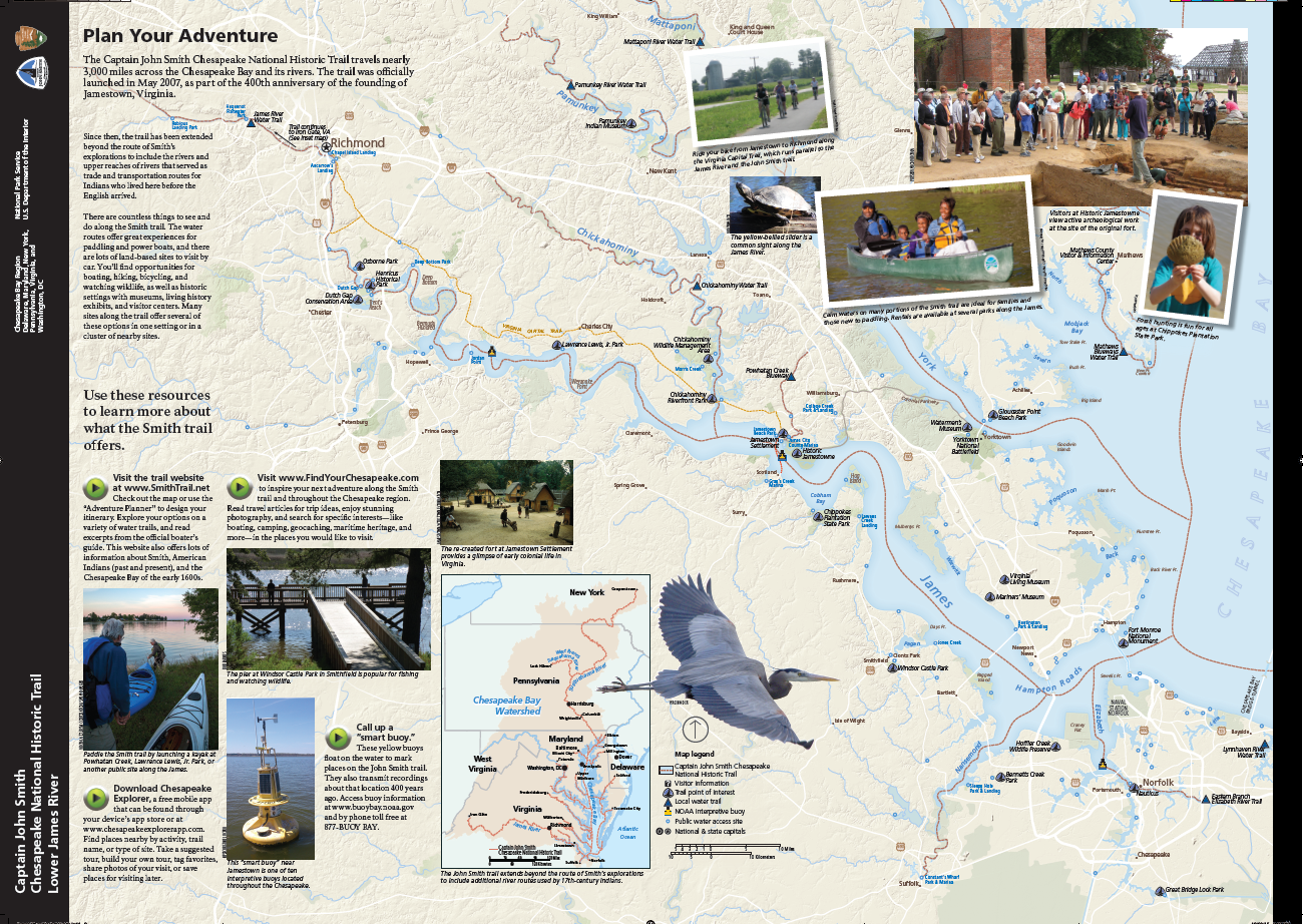
This portion of the river is also part of the Captain John Smith Chesapeake national Historic Trail, one of only two water trails designated as a “National Historic Trail”, the other being the Star-Spangled Banner National Historic Trail. The Captain John Smith trail consists of a series of waterways in the eastern USA covering approximately 3000 miles (4800km) flowing along the Chesapeake Bay. The waterways are of historic significance as they trace the 1607-1609 voyages of Captain John Smith on his expedition to chart the land and waterways of the Chesapeake.
In 1612, years after his expedition, John Smith was able to publish his map of Virginia, a masterpiece that would continue to be used for 7 decades.
Deep Bottom Park is a quiet and small getaway on the James River. About 20 minutes out from Richmond, the park provides access to the two boat ramps – one is a canoe launch facing Four Mile Creek, and the second is the main boat launch out to the James River. This section of the James River is uncharacteristically deep (hence the name of the park).
We were blessed with another beautiful spring day. The sun was out with temperatures in the low 60s F. Although not designed as a biking trail, our toddler found plenty of suitable ground to blaze through. We spent most of our time at the canoe launch, where we had the dock all to ourselves. From here, we were able to immerse ourselves into the surroundings and the wildlife welcomed us. We saw a large osprey, a large blue heron, fish jumping out of the water and countless frogs and tadpoles and everything in between.
From what I could see from the dock, the waterway up to Four Mile Creek, looked like a good one to paddle. The water was calm, and the wildlife viewing appeared promising. Whether your interest is history, wildlife, the river or fishing, there is something here for everyone. (Be safe out there, and always make sure you have your personal flotation device, PFDs).
Deep Bottom Park also offers picnic facilities, restrooms, and fishing are available at this site. The boat ramps are available twenty-four hours a day to launch and retrieve boats. The park grounds are open from dawn to dusk.
On my last day of break, I wanted to take the family out to explore the freshwater tidal marsh areas of R. Garland Dodd Park in Chesterfield County, Virginia on the Appomatox River. The park spans 176 acres and offers something for everyone of all ages. Apart from the beautiful 2.7 miles of walking trails, there are 2 baseball fields, 2 basketball courts, a football field and 6 tennis courts which are all lighted. There are also 4 soccer fields and two different sets of playgrounds, and numerous shelters.
The main attraction to the park is the floating boardwalk through the Ashton Creek Marsh. In the heart of winter, the place seemed desolate but still very beautiful. I imagine that in the summer, this place would be teeming with wildlife; birds, turtles, and dragonflies to mention a few. We enjoyed the very short hike down to the first Marsh Overlook where the floating board walk begins. Interestingly, at this location is another playground area which seems to be almost hidden in the woods. Our son very much enjoyed the floating boardwalk, as he hopped over the panels to avoid the small gaps. With walking stick in hand he explored the marsh and the plants, marveled at the ducks as they flew in formation and observed the sporadic movements of the dozens of tadpoles.
At the age of 28 months, he is a very capable hiker on flat terrain such as this. Towards the South Gully Bridge is a beautiful outlook on the Appomatox as the marsh opens up into flowing river water. This area is interestingly of historic significance as well. This land was the southern end of the Union position during the Bermuda Hundred Campaign. These were a series of battles fought at the town fo Bermuda Hundred during May of 1864 during the American Civil War. There is evidence of the Union Army’s earthworks in the area however relic hunting is prohibited in the park.
The park is listed as “at Point of Rocks”. The Point of Rocks is a plantation home that was built in 1840 of historic significance during the civil war. It was named after the 60 foot high sandstone cliffs on the Appomattox River. The house had signficance as an observation point during the war for Union General Benjamin F. Butler. It was used for a time as a hospital as well. The home today is owned privately by descendants of John Strachan, but part of the land is part of the park today.
Whether you come for the views, the sports or the history, there is certainly plenty to explore at R. Garland Dodd Park. (30 minutes away from Richmond, VA)
In March 2017, we took a trip to the southern most tip of South America to explore Chilean Patagonia. This was over 2 years ago, but I finally found some time to put together a video! It was filmed on my sony a6000 which I purchased in 2015, it amazes me how well this camera has held up over the years. It’s not 4K video, but the colors and image quality are still awesome in my opinion. It has been on a lot of trips in all types of weather conditions and survived. It is also a tiny camera so you can actually use it when the moment calls. Enjoy!
I normally wouldn’t log this trip as an expedition, but with a 19 month with us, it sure felt that way. My friend was getting married in Nasheville and he suggested that I head out a week early to explore the Great Smoky Mountains National Park as well as the surrounding Gaitlinburg area before the wedding. Gaitlinburg is listed at 6 hours and 41 minutes from Richmond, and I have always been looking for an excuse to go to the smokies. We felt like the distance might have been quite a stretch for our 19 month old son, but he has always been quite a good lil traveler so we decided to brave the roads instead of the airplane. He had never travelled such a distance by car before and I had no idea how he would tolerate it. So we ended up allotting a 12 hour travel window for us with scheduled 2 hour breaks in between so he could run and stretch his legs.
Roanoake River
Departure: 6:30am. The first leg of the trip went very well. We were able to get in 2.5 hours before our first stop in the town of Roanoake, Virginia. We stopped at Greenhill Park, and it was the absolute perfect pit stop. For a toddler, this park was like an oasis. It had it all, a playground, picnic tables, shaded areas, and even the roanoake river coursed through the park for fishing and cooling off. The bend of river that traveled through the park was very clear and shallow. It was perfect to wade and search for fish and crayfish. Our son loved this spot a little too much and as expected, it was a battle to get him back into the car…fortunately, the weather was merciful and by mid-day it was still surprisingly comfortable.
cabin views
Soon enough we were on 81 south again, as the interstate rolled gently through the hills towards Tennessee. We covered a couple of hours before we stopped again in Bristol, VA/Tennesee for lunch. We finally finished the leg to our cabin at about 4:30pm (a total travel time of 10 hours) 2 hours ahead of schedule! We actually stayed just outside Gaitlinburg in a town called Sevierville, Tennessee (population 16,716). We were all excited to stretch our legs, jump on the bed a few times, and get outside and take in some of the beautiful views. It did not take us long to get settled into our new home for the next 5 days and 4 nights. Our son instantly fell in love with the place and of course the air hockey table. We all rested easily that night, in a cabin up in the clouds after a long day of travel – we were pretty worn out.
Gaitinburg
Black bear.
smoky mountains
The next morning, we woke up early to head into the national park. The drive was a short and easy 20 minutes into the park. Out of all 60 national parks in the United States, the Great Smoky Mountains is the most visited park with more than 11.6 million visitors in 2016. This is likely due to the fact that it is one of the few parks on the east coast and it is also free admission. I was surprised to see the level of commercialization of the surrounding area. The town of Gaitlinburg is essentially one big tourist trap, with everything from “Ripley’s Believe it or not” to go carting! I personally found this to be off-putting but many people seemed to love it. I guess I always imagined the national parks as one of the few special places on earth protected to bring us closer to the outdoors. They are meant to inspire future generations to learn about the environment and the importance of different ecosystems. Instead, in Gaitlinburg, there are endless shops and stores that sell meaningless t-shirts and merchandise… all of which will likely end up in a landfill within a couple of months. While, Gaitlinburg can be very entertaining for children, it feels out of place so close to a national park.
The ascent up to Laurel Falls.
The park itself is very nice and actually very similar to Shenandoah National Park. We chose our hikes carefully…..something feasible with a 27lb 19 month old on your back. We arrived early in the park and were fortunate enough to get a parking spot at Laurel Falls. It was an easy one with only 314ft elevation gain over 2.4 miles. Our son particularly liked the Sugarlands visitor center where he finally got to meet a black bear (the goal of his trip). He even posed next to it for some pictures. He always seems to enjoy visitor centers at parks, whether they be state or national. They offer a quick run through of the key faun and flora in the park. We later head into Gaitlinburg to tour the town and find some dinner.
fog
on top of clingman’s dome
Now that we knew what we were up against, we wanted to rise early and get to Clingman’s Dome, the highest point in the park and in Tennessee. It is located in the heart of the park at an altitude of 6643 ft. Fortunately with a child, the parking lot brings you within one mile of the observation deck, where you make a steep ascent to be amongst the clouds. The temperature at this altitude was 52 degrees farenheit, a stark contrast from the 82 degree weather back at our cabin! Visibility fluctuates rapidly at this altitude as well, and we hunkered down in our CRV until the sun started to show. Interestingly, at this altitude, there was an information cabin and gift shop. We bought a sweater and a stuffed bear and hung around the parking lot until the sun came out. We caught our break when we caught a glimpse of Fontana Lake on the North Carolina side over a mile away. The climb up is steep with numerous benches along the way for visitors to take breaks. The landscape is pretty amazing with the distinct douglas fir trees that painted the horizon. The clouds moved fluidly over the mountains and created an ocean of moving shadows over the mountain range.
breakfast views
Up in the clouds
We would spend the next few days at the cabin, relaxing and taking in the surrounding views and listening to the sounds of the mountain range. We did occasional trips back out to Sevierville for supplies and food, but the pickings were slim. Of course, a trip to Tennessee would be incomplete without a visit to a local distillery for some bourbon. We picked up a couple of bottles from the King’s Family distillery as gifts for friends and family back home. All in all, our lil toddler loved the trip. The Great Smokies itself is a beautiful park. Perhaps one day, we might return to take on the most popular and strenuous hikes like Mt Leconte or Andrews bald, but I seriously doubt that we would be back in this area with so many more National Parks left to visit. I was surprised at how well he did in the car, and this gives me hope for future trips.
In May 2018, we took our 7 month old out west to see Yellowstone and Grand Teton National Park. I put together this video of our memorable time out west. Enjoy!